replaced http://history.stackexchange.com/ with https://history.stackexchange.com/
Source Link

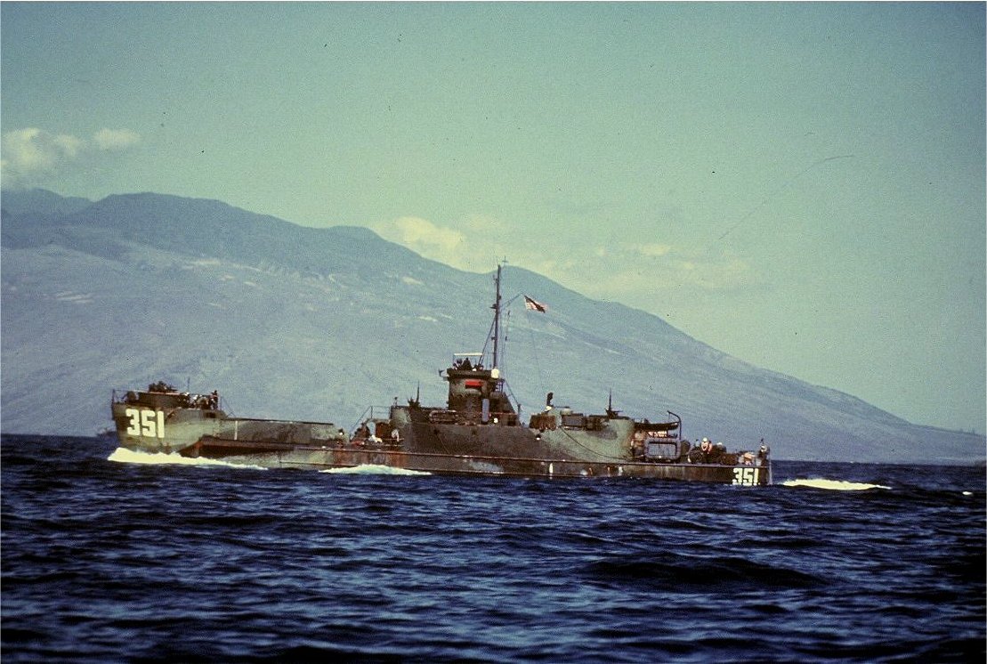
The stern is much too low to be an LSM. I'm 99% sure that it's LSI(L)-545, likely prior to departing for New Guinea in late summer of 1944. It was an LSI 341 class transport (class prototype below):
enter image description here

The bridge looks like the Golden Gate, but the only angle that would be right for that shot would make the island Alcatraz and I'm thinking that the buildings would be visible from that angle.

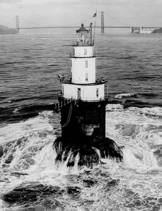
EDIT: After taking another scan around the San Francisco bay, it is possible that the photo was taken from the Mile Rocks lighthouse from roughly this direction, catching only the north tower of the bridge and zooming in on the departing ships:

UPDATE: I was totally wrong on the picture location. @AndyW correctly pointed out in his answerhis answer (and received my much deserved up vote) that this is the San Francisco Bay Bridge and Yerba Buena Island. Here's the same shot from Google Maps Street View.
The stern is much too low to be an LSM. I'm 99% sure that it's LSI(L)-545, likely prior to departing for New Guinea in late summer of 1944. It was an LSI 341 class transport (class prototype below):

enter image description here

The bridge looks like the Golden Gate, but the only angle that would be right for that shot would make the island Alcatraz and I'm thinking that the buildings would be visible from that angle.

EDIT: After taking another scan around the San Francisco bay, it is possible that the photo was taken from the Mile Rocks lighthouse from roughly this direction, catching only the north tower of the bridge and zooming in on the departing ships:

UPDATE: I was totally wrong on the picture location. @AndyW correctly pointed out in his answer (and received my much deserved up vote) that this is the San Francisco Bay Bridge and Yerba Buena Island. Here's the same shot from Google Maps Street View.

added 463 characters in body
Source Link
Comintern
  • 6k
  • 1
  • 22
  • 46

The stern is much too low to be an LSM. I'm 99% sure that it's LSI(L)-545, likely prior to departing for New Guinea in late summer of 1944. It was an LSI 341 class transport (class prototype below):

enter image description here

The bridge looks like the Golden Gate, but the only angle that would be right for that shot would make the island Alcatraz and I'm thinking that the buildings would be visible from that angle.

EDIT: After taking another scan around the San Francisco bay, it is possible that the photo was taken from the Mile Rocks lighthouse from roughly this direction, catching only the north tower of the bridge and zooming in on the departing ships:

EDITUPDATE: After taking another scan around the San Francisco bay, it is possible that the photoI was taken fromtotally wrong on the picture location. @AndyW correctly pointed out in Mile Rocks lighthouse from roughlyhis answer (and received my much deserved up vote) that this direction, catching only the north tower ofis the bridgeSan Francisco Bay Bridge and zooming in on the departing ships:

enter image description hereYerba Buena Island. Here's the same shot from Google Maps Street View.

The stern is much too low to be an LSM. I'm 99% sure that it's LSI(L)-545, likely prior to departing for New Guinea in late summer of 1944. It was an LSI 341 class transport (class prototype below):

enter image description here

The bridge looks like the Golden Gate, but the only angle that would be right for that shot would make the island Alcatraz and I'm thinking that the buildings would be visible from that angle.

EDIT: After taking another scan around the San Francisco bay, it is possible that the photo was taken from the Mile Rocks lighthouse from roughly this direction, catching only the north tower of the bridge and zooming in on the departing ships:

enter image description here

The stern is much too low to be an LSM. I'm 99% sure that it's LSI(L)-545, likely prior to departing for New Guinea in late summer of 1944. It was an LSI 341 class transport (class prototype below):

enter image description here

The bridge looks like the Golden Gate, but the only angle that would be right for that shot would make the island Alcatraz and I'm thinking that the buildings would be visible from that angle.

EDIT: After taking another scan around the San Francisco bay, it is possible that the photo was taken from the Mile Rocks lighthouse from roughly this direction, catching only the north tower of the bridge and zooming in on the departing ships:

UPDATE: I was totally wrong on the picture location. @AndyW correctly pointed out in his answer (and received my much deserved up vote) that this is the San Francisco Bay Bridge and Yerba Buena Island. Here's the same shot from Google Maps Street View.

added 497 characters in body
Source Link
Comintern
  • 6k
  • 1
  • 22
  • 46

The stern is much too low to be an LSM. I'm 99% sure that it's LSI(L)-545, likely prior to departing for New Guinea in late summer of 1944. It was an LSI 341 class transport (class prototype below):

enter image description here

The bridge looks like the Golden Gate, but the only angle that would be right for that shot would make the island Alcatraz and I'm thinking that the buildings would be visible from that angle.

EDIT: After taking another scan around the San Francisco bay, it is possible that the photo was taken from the Mile Rocks lighthouse from roughly this direction, catching only the north tower of the bridge and zooming in on the departing ships:

enter image description here

The stern is much too low to be an LSM. I'm 99% sure that it's LSI(L)-545, likely prior to departing for New Guinea in late summer of 1944. It was an LSI 341 class transport (class prototype below):

enter image description here

The bridge looks like the Golden Gate, but the only angle that would be right for that shot would make the island Alcatraz and I'm thinking that the buildings would be visible from that angle.

EDIT: After taking another scan around the San Francisco bay, it is possible that the photo was taken from the Mile Rocks lighthouse from roughly this direction, catching only the north tower of the bridge and zooming in on the departing ships:

enter image description here

Source Link
Comintern
  • 6k
  • 1
  • 22
  • 46
Loading