The maximum extent of de facto Nationalist control in China was achieved around 1946. This is after the Second Sino-Japanese War ended, and before the Second Chinese Civil War began in earnest. At this point, the Nationalist Government had recovered all of its pre-war territories (at the height of the Nanking Decade), and made several major additions including:
- Hunan - taken over politically after the Japanese invasion started
- Sichuan - gradually fell under central control as the wartime seat of government
- Yunnan - forcibly brought under control by a Nationalist army in 1945
- Shanxi - fell under control in 1945 as Communists decimated warlord Yen Hsi-Shan's army
- Shensi - Nationalist forces garrisoned the southern regions during the war with Japan
- Taiwan - received from Japan after the surrender
- North China - some parts taken over by Nationalist forces, including Peking
- Manchuria - Nationalist forces secured a coastal tract, from the Shanhai Pass to Mudken
The Nationalist government also extended its influence over the Guangxi Clique, and to a lesser extent other peripheral regions such as Tibet. However central government control was weak, if not purely nominal. The Guanxi Clique for instance could not be ordered; the government had to rely strongly on good will and common antipathy towards the Communists.
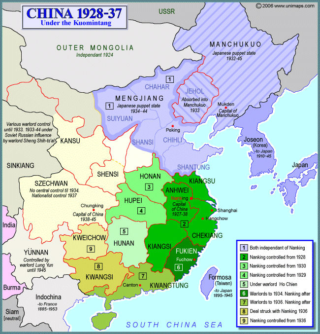
Unfortunately there doesn't seem to be any particularly good map to illustrate this. The best I've found is this map of the extent of Nationalist government influence before the Japanese invasion. The Nationalists controlled regions are in green [2-7] plus Kweichou [9]. Note that that central government did not have control over Kwangsi (Guangxi) [8].

As discussed above, after the Sino-Japanese War, the Nationalist government ultimately recovered all of its pre-war power base, and further gained control over the provinces Hunan, Yunnan, Sichuan (Szechwan), and Taiwan.
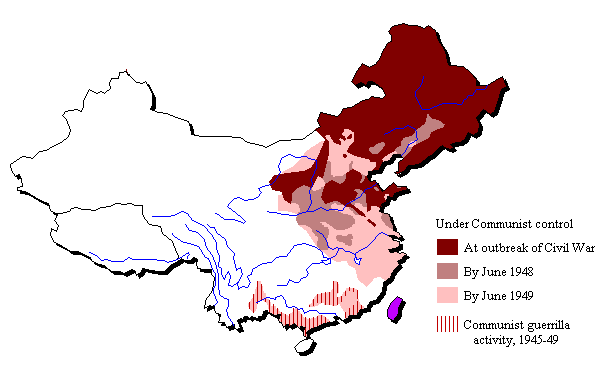
Nationalist forces also made gains in Northern China and Manchuria, including parts of Gansu, Shensi, Chihli, and Shanxi (Shansi). Borders were far more complex and fragmented in these regions however, and did not follow provincial lines. The following map of Communist areas in 1946, in dark brown the darkest red (burgundy?), illustrates by way of contrast the irregular extent of Nationalist control in these regions.


