2

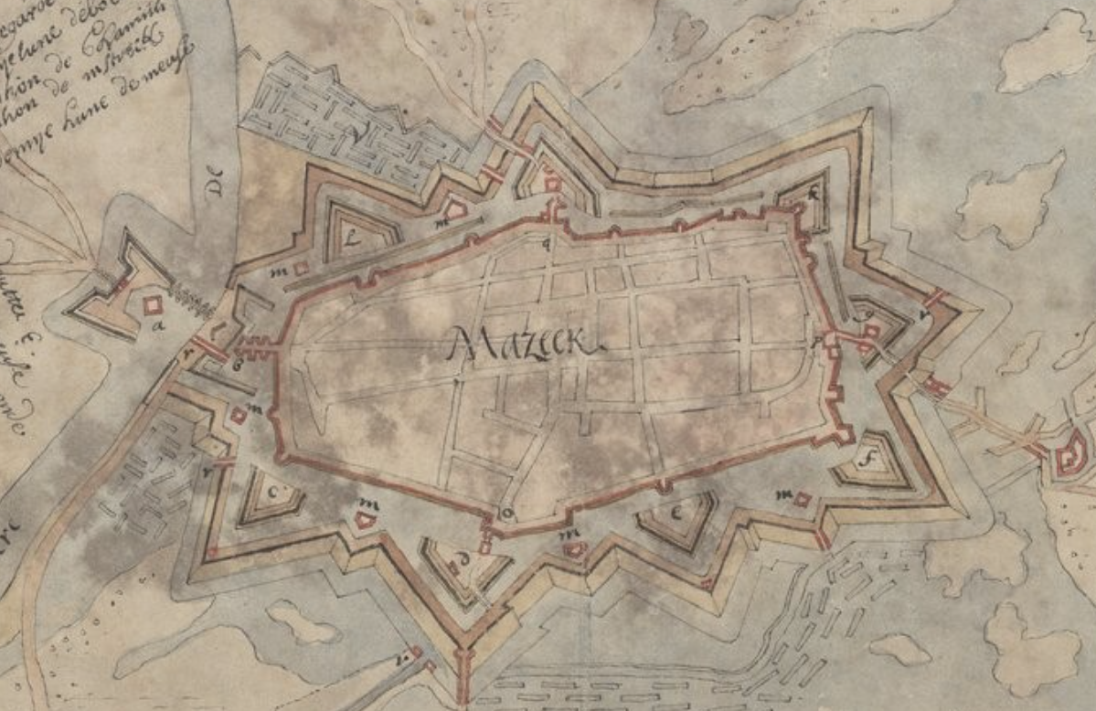
Using this 1675 map of Maaseik, Belgium, for example, there are hornworks, bastions, and ravelins at specific locations around the outer wall of the city. What determines why certain structures are built at those sites. Is it simply terrain, or are their other factors that determine the layout of the features.

enter image description here

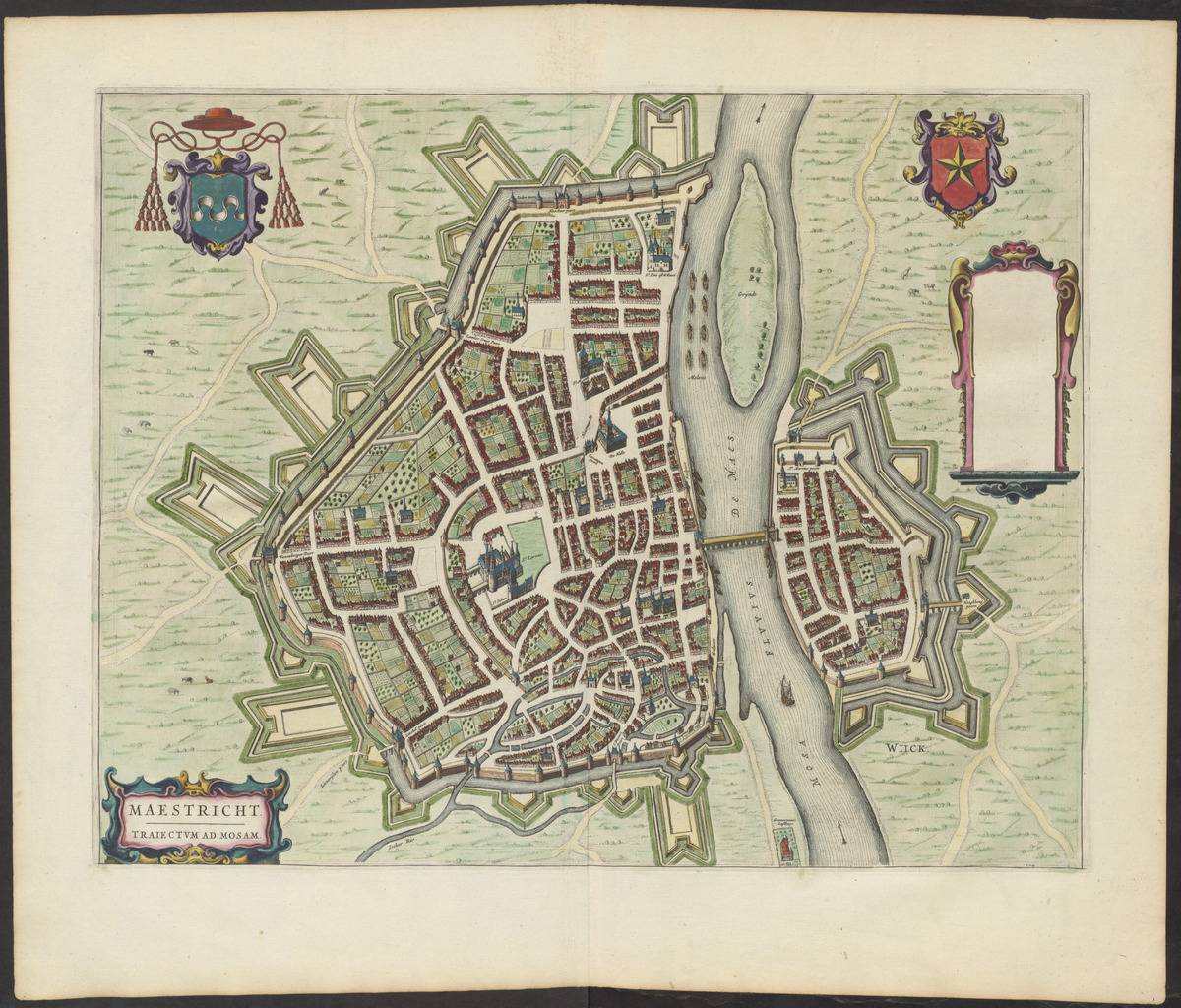
The map of Maastricht, from twenty years earlier, shows the placement of the elements seeming more random.

enter image description here

Toonneel der steden van de Vereenighde Nederlanden : met hare beschrijvingen

Scene of the cities of the United Netherlands: with their description Imprint [Amsterdam] : Joan Blaeu, Year 1651
9
  • 1
    Changed the headline which was extremely broad to match the body of the question.
    – Brian Z
    Commented May 10 at 18:52
  • I see I made the body of the question much too narrow, and edited it to make it more in line with my intention.
    – Bob516
    Commented May 10 at 20:40
  • 1
    @Bob516 I am a confused by the question. The placing of ravelins and bastions seems entirely conventional for fortifications of the time. Basically, they were arranged fairly equidistantly in a ring around the object to be protected. The hornwork in this particular case seems to guard the river crossing of the Maas itself: there may have been be a boom or chain across the river there in addition to a bridge but it is hard to determine from the image.
    – njuffa
    Commented May 10 at 20:41
  • @njuffa I am wondering why there is only one hornwork, at the gate along the river on the left side of the map and no hornwork at any other gate. I will add a map of Maastricht, which seems a bit more random in the placement of the elements.
    – Bob516
    Commented May 10 at 20:50
  • 1
    The bridge over the Maas looks peculiar on this map because it was a boat bridge (precursor to the modern pontoon bridge) according to the Dutch Wikipedia: "Over de Maas wordt een schipbrug geslagen, met een versterkt bruggenhoofd op de Schansberg in Roosteren."
    – njuffa
    Commented May 10 at 20:51

1 Answer 1

4
  1. There were treatises on the "scientific" placement of defensive works, notably by the Marquis of Vauban. But he was neither the first nor the last to write this up. They were designed to put flanking fire on any part of the wall from batteries further in. Distances and angles were determined by weapon performances.
  2. The geometry then had to be applied to the actual geography. There might be rivers or canals to help the defense, or to complicate it. Hills might have to be secured by outworks. Roads need gates.
  3. How much of this "theoretically perfect" defense one could give to a city or fortress would depend on the budget of the state. Each additional layer would prolong the expected siege, but each got larger and required more troops to man the perimeter.
  4. Budget problems could be relieved by using parts of existing fortifications. Those might be from a different era, when different weapons dictated different fortifications.

I cannot provide an expert analysis of Maastricht's defenses, but three things seem obvious when one thinks about them:

  • In the Maastricht map you link, the first obvious feature is the river Maas, splitting the city into the main city and the defended bridgehead on the eastern bank. The bridgehead defenses are on a smaller scale.
  • There is also the smaller Jeker on the south side of the fortifications, and fewer/smaller hornworks in the south where water helps the defense.
  • Another thing to look at is the placement of city gates, and how the roads from them cross the defensive works. They tend to go through or between ravelins rather than the larger hornworks.
5
  • This is very helpful, thank you. I most interested in the defensive structures around Maaseik (Mazeek) as I will be incorporating details about it in a novel I am writing. Do you have any thoughts about the structures beyond the original city walls (the inner outline of the city)? They were built by Vauban starting in 1672. I was curious why there is only one hornwork. Do you think the city was too small for more hornworks to be included?
    – Bob516
    Commented May 11 at 7:29
  • 1/2 The first map included in the question is almost identical to the one of the city of Rocroi (star-shaped defensive walls), as you can see on the french page on wikipedia. It was part of the second line of Vauban's "pré carré" as shown here.
    – OldPadawan
    Commented May 11 at 9:23
  • 2/2 Maastricht design might have been influenced/done by the Dutch Waterline but you'd have to do the research by yourself on this one :)
    – OldPadawan
    Commented May 11 at 9:27
  • @OldPadawan Rocroi seems close to being bilaterally symmetric. Mazeek (Maaseik) is clearly not symmetric along either axis. It is the asymmetry of Mazeek that is of interest to me. With Maastricht being around 110 km south of the Old Dutch Waterline I can't see how it would have been constructed as part of the waterline.
    – Bob516
    Commented May 11 at 13:38
  • Vauban designed the cities fortifications according to the ground, water and access paths. Some walls of the star were longer or shorter depending on the ground and the view needed by the ones defending the city, no city was a clone if another one AFAIR
    – OldPadawan
    Commented May 11 at 16:48

Your Answer

By clicking “Post Your Answer”, you agree to our terms of service and acknowledge you have read our privacy policy.

Not the answer you're looking for? Browse other questions tagged or ask your own question.