I am writing a piece that requires me to understand the route that ships would have taken from Liverpool to Cape Town in the 1840s. What I have not been able to ascertain is whether the ships would have stopped at any ports on the way, and if so, which ports. Is there anyone who can assist me?
-
They would not stop, unless there was a reason to stop.– AlexCommented Jan 16, 2021 at 17:15
-
4Since this is the 1840s, any passage would still be in a sailing vessel, following the trade winds down the coast of southern Europe and north Africa across the South Atlantic to the Brazilian coast and then back across the Atlantic to South Africa. That ~7500 nautical mile trip would take a couple of months, so I suspect that there would be at least one stop for fresh food and water along the way (quite possibly more if the passengers were rich enough).– Steve BirdCommented Jan 16, 2021 at 18:00
-
@SteveBird: Looking at the trade winds of the South Atlantic, there's no sane captain going to take that route south if he's got choices. That'll add weeks to the voyage - or months if one gets forced south to Sao Paulo or even Buenes Aires. It would require tacking upwind the whole way from Brazil to St. Helena and beyond. That's the downwind route northward though, for the return. Going to Cape Town I'd go Liverpool-Oporto-Tenerife-Cape Verdes-Ascension-St. Helena-CapeTown to stay upwind of the trades and allow reaching on the southward legs.– Pieter GeerkensCommented Jan 17, 2021 at 12:42
-
2005, The Gothenburg replica took the way by Recife. Because she is entirely able to do so.– Stefan SkoglundCommented Jan 17, 2021 at 13:22
-
1@StefanSkoglund: here is the note from the Gotheborg official site; "A few days into the new year 2006 The East Indiaman Götheborg left South America and Brazil and set course southwards along the South American coast to set course eastwards with the aid of the western winds belt. The trip from Recife to Cape Town in South Africa took about 40 days." That route goes far south of St. Helena and approaches Cape Town from the west rather than the north-north-west, a combination of (mostly) very comfortable reaches.– Pieter GeerkensCommented Jan 17, 2021 at 14:12
3 Answers
Sometimes it is best to look for specific examples.
When I see mention of ships heading to young colonies I go to genealogy sites to look for information. The Geni site has a list of British Ships to South Africa in the 1800's. The time frame you mention is a bit out of the main emmigrant wave in the late 1850s, but you can find a few examples from the 1840s. I located one which doesn't quite match your specifications, being out of Portsmouth instead of Liverpool, but I think the detail of information from the Geni page on the voyage of the Recorder from January to March 1846 might be useful for your research.
The link connects to a transcription, actual information from an actual journey which took place:
Journal of the Ship Recorder Bound to the Cape of Good Hope with Emigrants
The following is a transcription of the Journal held at the National Archives, Kew (Ref CO48/262). The Journal written by Mr William Williamson, Surgeon Superintendent on board the Ship Recorder during its journey from Southampton, England to Algoa Bay, South Africa from December 1845 to May 1846. It gives an amazing insight into life onboard an Emigrant Ship during this period.
Next a little concerning the ship and purpose of the voyage:
Emigrants leaving for the Colonies From Portsmouth Harbour
11 Dec 1845 Embarkation/ Inspection of berths etc Arrived on Board the Ship Recorder 630 ton register Captain SHARPE, chartered for the conveyance of Emigrants to the Cape of Good Hope, on Government bounty –
(emphasis mine ) Note this ship is not a general trader, but a passenger ship. Her purpose is to transport colonists, emigrants to Britain's new Cape Colony.
Here are some details are provided about the number of passengers:
Number of emigrants embarked on board the ship Recorder bound for the Cape of Good Hope.
ADULTS Married: 39 males, 39 females 78 total Single: 59 males, 13 females, 72 total Totals: 98 males, 52 females, 150 total
CHILDREN Between 1 and 14: 29 males, 30 females, 59 total Under 1 year: 4 males, 6 females, 10 total Totals: 33 males, 35 females, 69 total
Total no. of Souls: 219 Or equal to 179 ½ statute adults
I certify the above mentioned to be the number of Emigrants delivered into my charge on board the Ship Recorder and that there is not apparent among them any sickness of consequence, or any infectious disorder capable of proving dangerous to the passengers: Signed: Mr WILLIAMSON MD, Surgeon Superintendent Plymouth Sound, 9th January 1846
So 219 passengers are ready to be begin the trip as recorded on 9 Jan 1846. The journal then continues on a day by day basis, much to extensive to preproduce in answer form here. It details daily weather, discusses other ships encountered along the journey, occasionally recording Latitude and Longitude positions. Interesting to glance over, and some mundane details of crew and passenger issues are mentioned, providing some insight into the journey.
The ship arrives at Cape Town (Table Bay) on April 12th after a 3 month (93 day) voyage:
12th Arrival in Table Bay By 6’o clock am sighted Table Mountain bearing S E by E. The wind lulling all sail was set again & by 8 o’clock we neared the Bay with the Lions Head and Rump arising in strong outtrue? Before us. By 12 noon we cast Anchor in Table Bay and at 2pm (our arrival having been telegraphed before we entered the Bay) we were boarded by the Harbour Master who enquired into the state of health of Emigrants & crew and entered into the usual arrangements. Reported to the Colonial Secretary the arrival of the ship with General Statement as to the state of health etc of the Emigrants.
Concerning the number of stops, there were none. A synopsis of the journey at the end of the journal, emphasis mine:
Return of Emigrants embarked & disembarked
Southampton – Port 11th December 1845 – Date of Arrival 11th December 1845 – Date of Embarkation 16th December 1845 – Date of Sailing
Plymouth – Port 4th January 1846 – Date of Arrival 4th January 1846 – Date of Embarkation of Emigrants 9th January 1846 – Date of Sailing
No ports paid into until vessel at Table Bay
Table Bay – Port 12th April 1846 – Date of Arrival 29th April 1846 – Date of Sailing
Algoa Bay – Port May 1846 – Date of Arrival
Number of Emigrants Embarked – 150 adults, 19 children over 7, 50 children under 7, 219 in total
Death on passage – 1 child under 7 and in total
Birth on passengers deck – 2 children under 7
Total of souls on board – 150 adults, 19 children over 7, 52 children under 7, 220 in total
No. Landed at Table Bay – 127 adults, 15 children over 7, 46 children under 7 No. Landed at Algoa Bay – 23 adults, 4 children over 7, 5 children under 7 Total number landed – 150 adults, 19 children over 7, 51 children under 7, 220 in total
Death on Board Susannah DUDLEY aged 1 year and 7 months daughter of William Dudley. Died of billiary disarrangement [the rest is illegible]??? 10th March 1846
Births: Mrs Geo PURCHASE of a female child 12th March 1846 Mrs Robt. Chas REID of female child 25th April 1846.
I hereby certify the above to be a true return of the Emigrants placed into my hands on board the Ship Recorder.
Signed William WILLIAMSON Surgeon Superintendent Algoa Bay May 1846
The ship Recorder was large enough (630t) to carry over 200 passengers and enough provisions to complete the journey in roughly 90 days without any stops. It is difficult to tell from one example if this should be considered 'typical', but one journal entry from April 3rd gives us a hint as to what was considered 'normal' (emphasis mine):
Today makes 16 weeks since we sailed from Southampton at which time we naturally expected to have spent 3 or 4 weeks in South Africa by this date.
It would appear they expected the journey to last about 12 to 13 weeks.
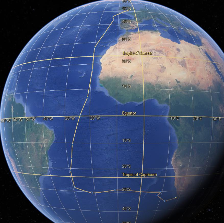
After putting some data points from the journal into Google Earth, the course followed appears something like this:
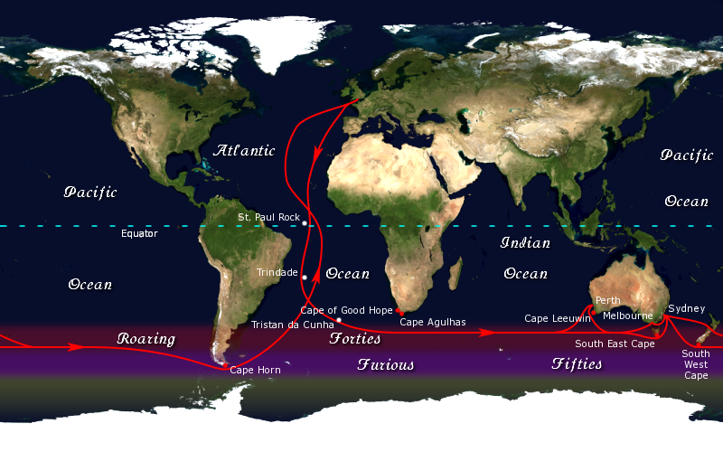
This can be compared to the first section of the map from the Wikipedia entry on the Clipper Route, which ended up going farther south to catch the winds to go on to Australia and New Zealand. But both courses crossed near the Island of Trindade as a western-most landmark (March 5 in the Recorders' logs).
-
-
1
-
That the voyage took so much longer than expected speaks to probably having been blown off course, and much further west than planned for. Commented Jan 17, 2021 at 22:59
-
1Possibly, but on March 5th they recorded crossing west of the Island of Trinidada (Trindade). This coordinates exactly with that portion of the Clipper route used by ships to go East out of Europe.– justCalCommented Jan 17, 2021 at 23:19
-
Other voyages: in 1850, the Emily sailed from Liverpool to Natal in 77 days "despite her age and condition." The Wilhelmina took 88 days for the same voyage in the same year; according to a passenger, the trip was "much more pleasant and prosperous than the voyages of many immigrant ships which had been landing passengers in Port Natal, during the previous 12 to 18 months." Commented Jan 18, 2021 at 17:00
There are likely too many variables to imagine a single best route. However two key considerations must be kept in mind:
Square-rigged and mixed-rigged vessels of the time struggled to point within 60 degrees of the wind - a much worse performance than the 45 degrees managed by modern racing yachts. Captains will do everything possible to avoid lengthy upwind passages: not only are they dreadfully slow, but they are hard on crew and vessel as well.
The captain and crew will have a home port. For this case, assuming that to be Liverpool likely makes the most sense. The routes out and back should be regarded as a unit.
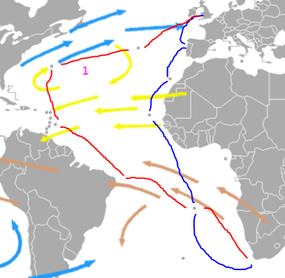
That said, If I was a sea-captain of the era the following route would be near the top of my list for a passage to Cape Town (blue) and back (red):
Liverpool
Oporto
Tenerife (Canary Islands)
Cape Verde (Cape Verdes Islands)
St. Helena
Cape Town
Ascension
Recife (Brazil)
Barbados and/or Trinidad & Tobago
Bermuda
Azores
Liverpool
Note how both routes, there and back, both ride the winds favourably to avoid tacking passages. Remember also that passengers probably number only a half-dozen or so - the vessel is a freighter, plying wares around and across the Atlantic for profit, and possibly only accepting passengers as a favour to a beneficial patron.
As an aside, this route also illustrates how, and why, Brazil was discovered so early by Portuguese explorers returning from the Cape. Prior to the longitude problem being solved, the northward passage was made far out into the Atlantic to ensure avoiding shoals in and around Cape Verdes. Once a captain knew the vessel was well safe, the passage north would be made to the correct home-port latitude; and then trade winds ridden east all the way home. Not unlike this proposed route.
Thanks for the input guys. I am pretty sure that the route was along the west coast of Africa, and that on at least one trip I found there was at least one stop at the Canary Islands. And I have read of a stop at an island of Equatorial Guinea, both stops enabling the ship to take on board supplies and water. What I am not sure of was whether there were likely to be other stops along the coast, particularly as they got further south. Certainly no talk in the literature that I have come across of going via South America. But thanks for the stuff on the trip with no stops. It seems like there were a number of options and variations. Good to know. thanks
-
2If you have more specific information, such as ship names and dates, please include it in your answer.– justCalCommented Jan 18, 2021 at 17:36


