5

The Fucino Plateau, in central Italy, is a wide plain arising from the drainage of the Fucino Lake in the late 1800s.

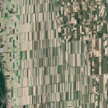
Looking at it in google maps, its fields are separated by roads set in a precise orthogonal grid. At first glance, the grid seems aligned to the cardinal directions, but this is not precisely true: if my measurement is correct, there is an offset counterclockwise by an angle of 1.2 degrees.

Rescaled Google Maps satellite view

This Google Maps satellite view was compressed along the horizontal axis to make the tilt of the roads and fields visible.

A historical map from 1875 (just before the drainage works were finished) shows the road grid already, so the alignment choice must have been made before that time.

https://it.wikipedia.org/wiki/File:Lago_Fucino_1875.jpg

My question is: why would the roads be misaligned in such a way? Was it intentional or an accident? Surely in the 1800s, the measurement of the cardinal directions would have been more precise than 1 degree.

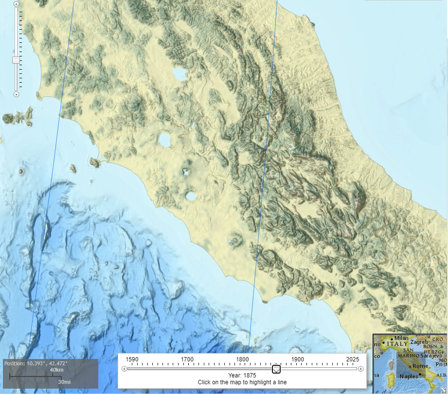
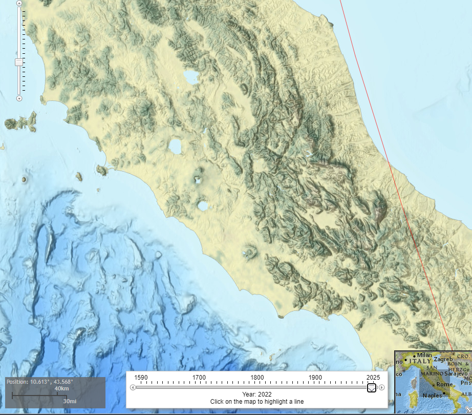
A hypothesis: this might be related to the magnetic north pole; however with this calculator I can see that the declination angle was much further West than 1 degree in the 1800s, and the roads of Fucino were aligned to magnetic north only around 1966-67, a good century after the plans must have been made.

13
  • 3
    Perhaps no one cared enough to make it a precise north-south alignment. Sometimes near enough is near enough. Or perhaps there's a presentation error in Google maps, quite often there are notable differences between the map data and the overlaid satellite photography. Again near enough is for most people near enough.
    – Steve Bird
    Commented Nov 13 at 16:29
  • 3
    I guess "large" is a relative term. Being off by a degree when using a protractor on my own drawings (consistently and in the same direction) would hardly be noticeable to the untrained eye. Being off by that much on a satellite launch would likely kill the mission. I'm not sure why this particular use should be considered closer to the latter than the former.
    – T.E.D.
    Commented Nov 13 at 17:10
  • 2
    I'm immediately wondering about the precision of instruments available to 19th century rural Italian civil engineers.
    – SPavel
    Commented Nov 13 at 17:18
  • 2
    Just two observations: The 1875 map doesn''t show its exact orientation (there's no Compass rose), so it isn't clear if it should be exactly aligned at all. Additionally, the road grid isn't aligned exactly with the map borders.
    – tohuwawohu
    Commented Nov 13 at 17:29
  • 1
    @tohuwawohu Indeed, the purpose of showing that map was mostly to give an upper bound for the date of the road plan. There isn't a rose, but it does look north-aligned, and I agree that the roads are visibly misaligned with the map edges. Commented Nov 13 at 17:35

3 Answers 3

6

There is a second, older map showing a proposed grid in

Leon de Rotrou: Prosciugamento del Lago Fucino eseguito dal principe D. Alessandro Torlonia: Confronto tra l'emissario di Claudio e l'emissario Torlonia, Firenze 1871.

Google Lens finds one other version of this map. Its resolution is not really better, but the coloring helps a bit.
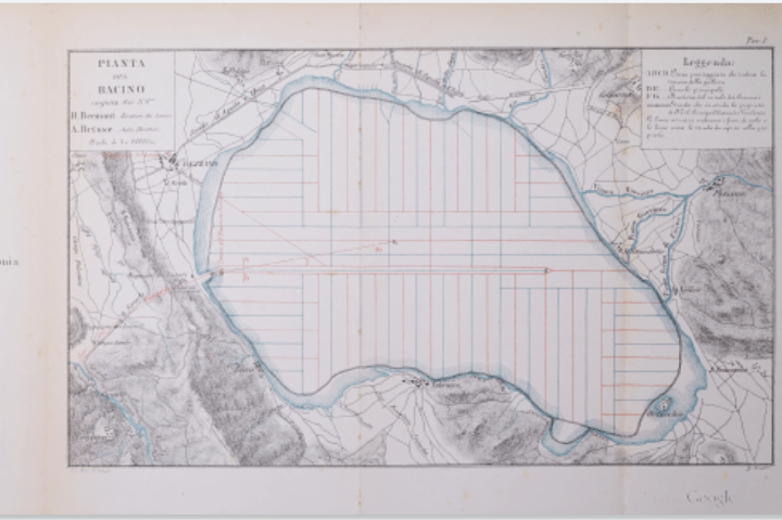
Plan of Fucino by Leon de Routrou

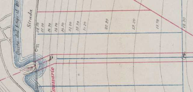
The descriptive text of de Routrou talks of a line FG that the author speculates was the direction of the antique feeder canal, while the modern one (already built), extended in the direction DE. It seem these are the lines extending from the western side of the map, the red one diagonally versus NE being the "antique" FG, while the blue one between the parallel streets is the "canale principale" of your map.

Work on that canal had started in 1871. While the inlet to the modern tunnel was finished, drainage was interrupted between February 1868 and January 1870. Alexandre Brisse, Léon de Rotrou: Desséchement du lac Fucino, execute par S.E. le prince Alexandre Torlonia: précis historique et technique, Rome 1876, p. 188 gives numbers for the level of the lake. In 1868, it stood 20.28m above datum and raised again to 21.85m in 1870. Your map shows these datum lines, and they are less then halfway to where the first north-south irrigation ditch would be. Everything east of that would still have been under water.
enter image description here

The pumping station which today is situated at Borgo Ottomila, is not included in the older map, and the eastern terminus was never realised. If you look closely, it seems that the blue line of the principal channel at its western end is not exactly parallel to the surrounding streets, but more to the south. If you connect the outermost points, the misallignment to the grid lines is less than 0.2°, but if you only look at the part west of the first north-south irrigation ditch, you could opine that it is more slanted there. (Note that by neccessity the channel was built from west to east, following the lowering of the lake's water level during its draining.)

That leads me to the speculation: In de Routrou's planing, the grid of roads and irrigation channels was alligned to the cardinal directions. But for reasons unknown, the main drainage channel turned out to be misalligned. Or, de Routrou noticed that and planned a slight curve to the right while extending the channel to correct, but that curve was never built. Then, it seemed to be more convenient to use the direction of that main axis to realise the grid, going perpendicular from its direction.

120km of roads and 100km of drains (pp. 191–192) were already built at the time Brisse and de Rotrou wrote their 1876 report. They describe the grid like this in comments (p. 275) to another map of the estate. (The plates were published in a separate tome, which has not been digitized. There are some low-res photos, but none of this map I could identify):

In the Eastern and Western parts of the estate the roads and the drains follow a direction parallel to the central canal. Those opened in the Northern and Southern parts are likewise parallel to each other, but run at right angles to the central collector into which the drains discharge their water.

Obviously, this only transforms the question to "why is the channel misaligned?"


Equal distances and right angles might also have been a marketing tool. As Leon de Routrou, who was the chief adminstrator of the project company writes:

The houses intended for the habitation of the farmers are also distributed regularly over the entire surface of the basin..., [each] having 25 hectares of land attached. It is not necessary here to examine the reasons which determined such a distribution of the land, which in itself is suitable for facilitating good cultivation, since the same can be easily understood by everyone.

2
  • 1
    It seems plausible that the alignment arose from the main drainage channel! I hope de Rotrou's account mentions this somewhere. Commented Nov 15 at 17:02
  • @JacopoTissino added an appropriate quote.
    – ccprog
    Commented Nov 15 at 18:08
0

The Earths magnetic poles move over time, causing the direction of "magnetic north" to vary with time. m

Here is the direction of magnetic north over Central Italy in 1875, based (most likely) on observations at Pola Observatory in Northern Italy:

enter image description here

Here is the current equivalent:

enter image description here

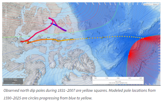
Note that the change from 1875 is quite dramatic. This is (at least in part) due to a relatively recent increase in both the speed and motion range of the magnetic north pole in recent decades. Here is a record of its position from 1590 to the present:

enter image description here

Navigation: Variation and Declination gives a summary of how to use the known local value of variation to move between compass and true north when navigating. Note that in cases where the hull/fuselage of one's vessel is magnetic, an additional correction, for what's known as "deviation", must also be made. Old time mariners learned the rhyme

Timid Virgins Make Dull Company; Add Whiskey

for remembering the formulas

True + Variation = Magnetic;   
Magnetic + Deviation = Compass;  
Add Westerly  (and therefore subtract easterly).
1
  • 1
    Hint: if you choose the "World imagery (Esri) as basemap and the year 1873, you can see a magnetic line over the arial picture of the fields. They do not line up.
    – ccprog
    Commented Nov 15 at 23:06
-5

Human visual perception is limited by the resolution of the retina. The retina contains 6 million come cells which is 2,500 per side. This means that anyone eyeballing a value will be off an average of 0.04% due to retinal resolution alone. This is .14 degrees.

An error of 1.2 degrees means that the people building the road used a visual reference point that was wrong by eight ocular rod cells. For comparison anythinf considered a visible object by humans is generally considered 16x16 pixels (eg, the favicons on stack exchange).

The road builders actually outperformed the visual density of the human retina but that is the cause of the error.

2
  • 7
    Have you ever heard about the ingenious invention of the telescope?
    – ccprog
    Commented Nov 13 at 20:58
  • This answer appears to assume that the engineers who laid out the roads "eyeballed" them. Much modern surveying equipment had been invented before the 19th century.
    – Robert Columbia
    Commented Nov 16 at 1:15

Your Answer

By clicking “Post Your Answer”, you agree to our terms of service and acknowledge you have read our privacy policy.

Not the answer you're looking for? Browse other questions tagged or ask your own question.