A large factor in the advancement/financial disparity between the U.S./Canada and its neighbors to the south is the difficulty of colonizing areas in tropical/subtropical climates vs. colonizing temperate areas.
(If I remember correctly this is somewhat covered in Jared Diamond's Guns, Germs, and Steel, but of course anyone playing Civilization or a Paradox history game such as Europa Universalis knows you stay away from the jungle.)
(From Reference.com: "Areas with temperate climate enjoy weather conditions without large temperature extremes and with rainfall occurring throughout the year.")
Before modern medicine (and even today), people living in warm or hot areas were more subject to disease (such as malaria, which continues to kill hundreds of thousands of people each year in tropical climates throughout the world), with livestock and the crops that have generally sustained civilization more subject to disease as well. Additionally, the grains and other crops such as wheat and potatoes that kept civilization going were grown in temperate climates and were less likely to die off due to extreme variations in weather.
For more on the crops that sustained settlers and where they were grown, see T.E.D.'s answer on another related question here. Note he refers to indigenous peoples being removed from temperate areas for farming land - one of the reasons you don't have large indigenous populations in temperate countries like the United States or Argentina, both of which received the largest influx of immigrants and both of which conquered and removed indigenous people. Note that Argentina has a larger GDP per capita than most Latin American countries, and has historically been somewhat more stable.
Combine this with the difficulty of taming the jungle vs. taming a temperate forest, and the ease of colonizing the United States vs. that of colonizing much of, for instance, Brazil becomes apparent.
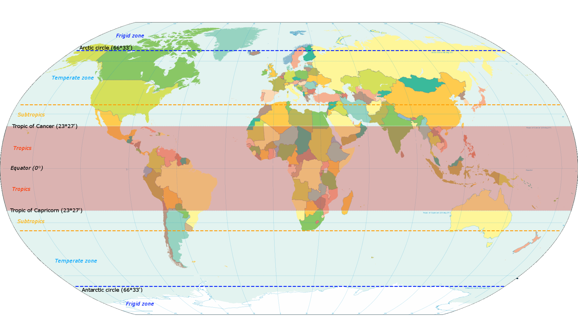
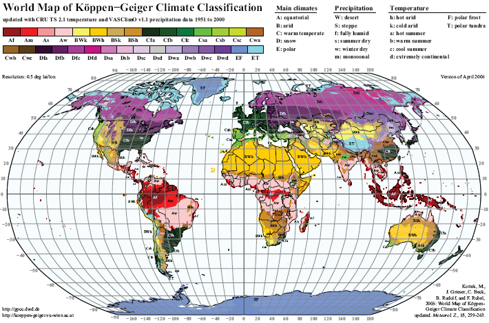
Please see a simple map of the areas in temperate zones vs. the areas in tropical zones below. A more complex climate map (vs. simple zones) is shown at the bottom of this post, and one can easily see the overlay of "bad climate to live in" works pretty well with the overlay of "GDP per capita."
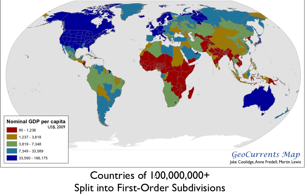
Compare this to pretty much any GPD per capita map:
First of all, note that the colonizing nations were all located in the temperate zone of the northern hemisphere, (where pretty much all the people who lived in a temperate zone lived back then).
Secondly, note that many of the states in the United States with the lowest income are in the subtropical areas of the country (only Mississippi shows this on the GDP map, but it remains true for the much of the southeast). I currently live in Florida, which benefits from a robust tourist industry and isn't as bad off as where I'm from in Alabama, and not many people lived in Florida until the invention of air conditioning and modern medicine (and without either of those I wouldn't live here). Note that even the hottest parts of Florida are above the Tropic of Cancer.
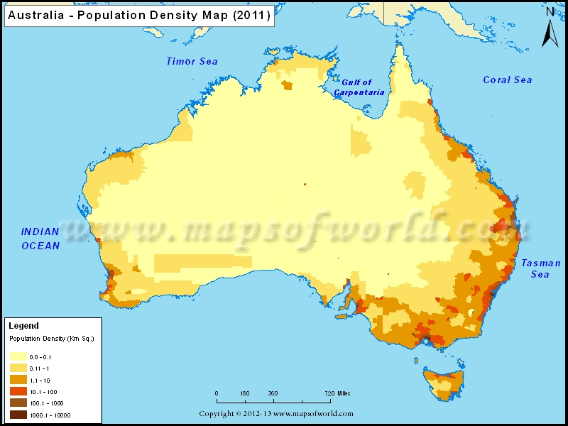
For another example, see that tiny part of Australia that lies in the temperate zone, and the borders closest to it? Compare it with this map of population density:
Most Australians live in or near the edge of the temperate zone, and even those people were dragged there from England, which was exactly in the middle of the temperate zone. One might also compare Australia and New Zealand and their places in or near the temperate zone and their higher GPD per capita than their neighbors to the north.
Now take a look at Uruguay, Argentina, and Chile, all of which have a relatively high GDP per capita compared to the rest of Latin America. These are the only major parts of South America in or near the temperate zone, and the latter two are covered by the Andes mountains, which does not make for easy settlement. They are relatively free of malaria risk, however, and their higher GDP per capita compared to other Latin American countries may be a result of this and other similar traits they share.
On a similar note, as I mentioned in the beginning of this post, Argentina's climate caused it to receive a vast number of immigrants in comparison with the rest of the world, largely displacing its indigenous peoples. "The strength of the immigration and its contribution to the Argentine ethnography is evident by observing that Argentina became the second country in the world that received the most immigrants, with 6.6 millions, second only to the United States with 27 millions, and ahead of countries such as Canada, Brazil, Australia, etc."
As Santiago wrote in a comment below, the area of Asia that lies in the temperate zone seems to be an anomaly on the GDP map, but it is important to note that this area is sometimes called the "third pole of the world" for a reason:
(As T.E.D. states in the answer I linked earlier in this post, areas in green and tan are good for growing crops, and in the case of this map dark purple isn't terrible. Meanwhile, these areas are not as prone to disease.)
While this area of Asia is in the temperate zone, the actual climate is cold and arid.
As for politics: the politics of places that have a higher GPD per capita and less strife between indigenous peoples and immigrants are generally better over the long term.


