11

This question came to our mind as a long discussion in chat between some users over ELU including me and we thought to post the question here. Wikipedia states he thought he had arrived Japan.

In his first journey, Columbus visited San Salvador in The Bahamas (which he was convinced was Japan), Cuba (which he thought was China) and Hispaniola (where he found gold).

That made us think, what made him think so? In the mean time, Cerberus came up with a helpful map of his journey, but we could not conclude anything from here. So does anybody have any information on this? We would really like to know.

The Map is uploaded separately for the users convenience.

Columebes Journey overview

11
  • 1
    Did Columbus even know that Japan existed? Commented Sep 27, 2013 at 5:44
  • @FelixGoldberg, Apparently, we don't know for sure. If you have some idea, share with us.
    – Mistu4u
    Commented Sep 27, 2013 at 5:47
  • 2
    Is there a source for the idea that Columbus thought he was in Japan? Commented Sep 27, 2013 at 5:48
  • 5
    Also, that map of Columbus voyages is completely wrong. en.wikipedia.org/wiki/File:Viajes_de_colon_en.svg Commented Sep 27, 2013 at 8:41
  • 2
    That map is not referring to the various voyages of Columbus. Columbus never even reached the North American mainland. Hard to say exactly what it's referring to... what is the source of that map?
    – user2590
    Commented Sep 27, 2013 at 10:21

5 Answers 5

12

My understanding is that the question is not regarding why Columbus believed he had reached Asia at large, but why he mistook San Salvador for Japan. If so, the answer (lacking the relevant primary source material) appears to be as follows:

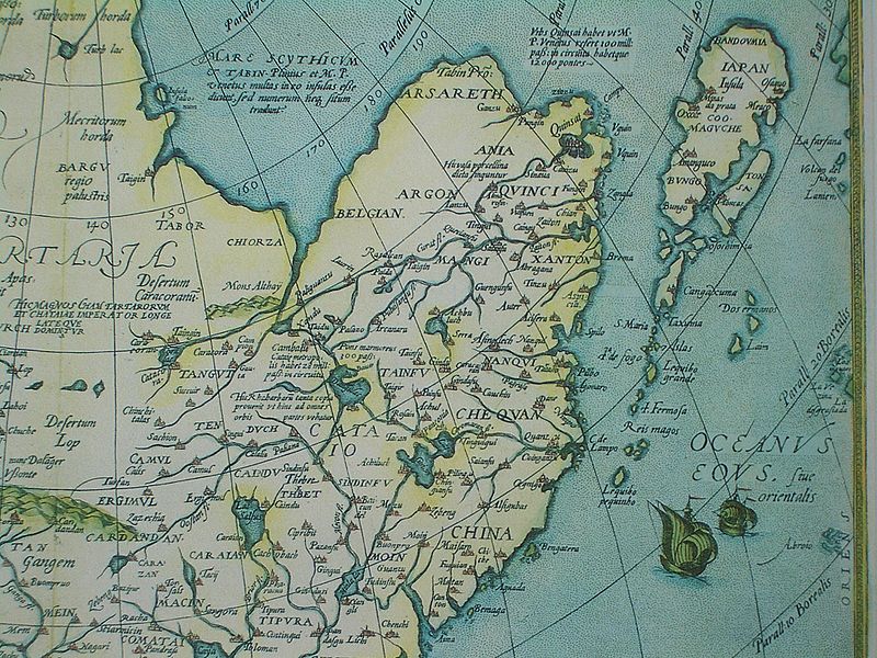
The Bahamas, which he believed were Japan, are north of Cuba, which he believed was China. (according to the question's source) At that time, the West was familiar mainly with the southern portion of China, which was more accessible to Europe by land via India and Indo-China, or by navigation along the southern coastlines. If so, Columbus, as well as most Europeans familiar somewhat with the Orient, would have understood that Japan was north of China, since Japan is indeed north of the southern coastal regions of China, those regions which the West at that time typically identified as China.
enter image description here

Map of Eastern China and Japan, published in 1570. Note the region label China, and the illustration of ships coming from the south in the East China Sea, towards Japan in the north and China to the south and west. In light of this map, Columbus's opinion regarding the Bahamas and Cuba is quite understandable.

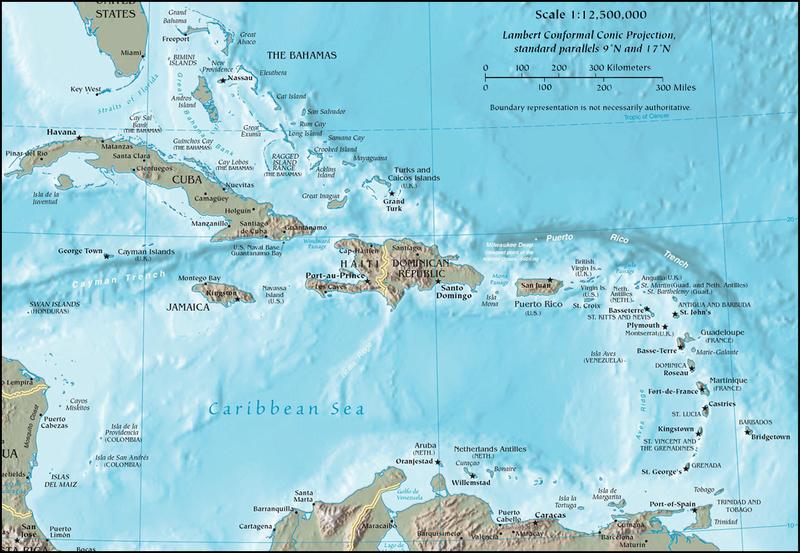
We might also add that the Bahamas are a chain of islands, similar in that respect to what was presumably known regarding Japan, whereas in comparison, Cuba appears to be a large landmass, similar to what was known about China.
enter image description here

Contemporary Map of the West Indies, showing prominently Cuba and the Bahamas.

If so, it would be logical to conclude that if he were indeed in Asia, the more northern island he discovered, an island in the Bahamas, was Japan, and the land to the south, Cuba, was China.

If he immediately believed he was in Japan upon landing, it would have been because his charts indicated he was heading towards the more northerly regions of his intended Asian target, i.e. Japan. If he only concluded the Bahamas was Japan after reaching Cuba, it would have been apparent that Cuba was south of the Bahamas, and so the the Bahamas were Japan and Cuba was China.

If this is not the question, then my answer is superfluous, and LateralFractal's answer is excellent.

3
  • Fascinating map. Did the old cartographers create inland lakes and northern seas out of thin air? In any case, I rather wish Amerigo Vespucci was better known; he didn't make the same mistakes that Columbus made. Commented Sep 27, 2013 at 13:37
  • 1
    @LateralFractal-They did not create those things. On a modern map of China you will see large lakes in the highlands of Yangtze and Yellow Rivers, similar to what's on the old map. Their maps were surely based on observations of people who had been there, or even Chinese sources. But they didn't have any good way of knowing and representing precise size and scale, or the accurate contours of the large land masses. They knew something like in the "northwest province there is a great lake called x that feeds the Great River, so they put something on the map to indicate that as best they could.
    – user2590
    Commented Sep 27, 2013 at 16:35
  • @LateralFractal (continued).. And there are northern seas like on the map: The Arctic Ocean. But again, they did not know the exact contours of the great land masses, they just knew something like "up north is a great sea." You cannot really know the contours of the continents or any large land masses unless you navigate or travel around them and make scientific measurements (or take an airplane or satellite ride..) - in 1570 that had not yet been done.
    – user2590
    Commented Sep 27, 2013 at 16:40
13

Christopher Columbus thought the world was spherical (like most educated people of his era) but he also thought the size of the Earth was small enough that a westward boat trip from Europe to Asia was achievable with existing ship building technology.

In this regard he differed from the more accurate size estimates of scholars in Isabella and Ferdinand's court. Sustained lobbying won out through - and so off he went.

Since he still believed the size of the Earth was small - when he bumped into land in the Americas obviously he would assert that the landfall was in Asia (India, Japan, China or somewhere) as:

  1. It fit his existing beliefs.
  2. Direct trade with the other end of the Silk Road was a vastly more profitable proposition than an unknown landmass.

These geographical fabrications are not new; the slabs of ice, rock and tundra that make up Greenland was named "Greenland" by Erik the Red to encourage settlement.

2
  • This is essentially my understanding as well. Columbus believed because he wanted to. I got the impression the main reason F&I eventually gave in was more the worry that he'd go to another government (namely Portugal) and by some fluke turn out to be right, more than that they were convinced of his theories.
    – T.E.D.
    Commented Sep 27, 2013 at 17:57
  • Heh. So, an early version of catb.org/~esr/jargon/html/S/SNAFU-principle.html
    – DVK
    Commented Oct 1, 2013 at 13:28
6

Columbus' original goal in his voyage was to reach Asia, to visit Japan and have some of its riches (spices, gold ...)

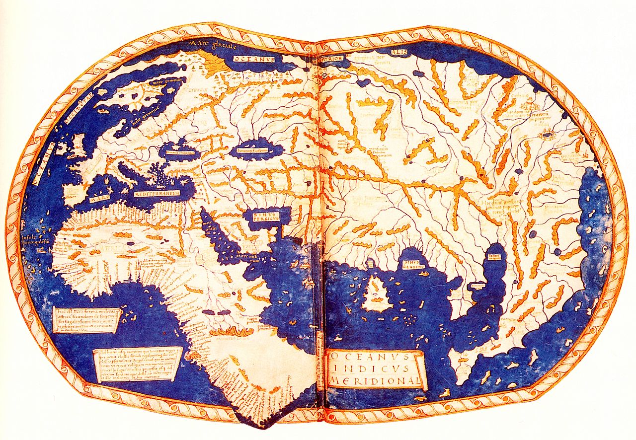
I guess Columbus thought the world map looked like this. (America doesn't exist.)

map around the year 1300

He thought if he traveled towards the west, he would reach Asia. He didn't know that the world map was different and that America exists in between.

8
  • 1
    @LennartRegebro - it was neither. It was simply ignorance - incomplete information.
    – user2590
    Commented Sep 27, 2013 at 8:56
  • 4
    @Vector He was well aware of better and more accurate calculations, but he chose to ignore them, because it didn't fit what he wanted to hear. He optimistically bet on that the majority/consensus was wrong. That's not ignorance or incomplete information, that's over-optimism (or possibly self-delusion if you want to frame it in a less positive manner). Commented Sep 27, 2013 at 9:12
  • yeah, but anyways not because he's dumb
    – Louis Rhys
    Commented Sep 27, 2013 at 9:20
  • 1
    @AnkitSharma - that's OK. We do try to be serious minded here... :-)
    – user2590
    Commented Sep 27, 2013 at 11:01
  • 1
    @moudiz - if you have a question, why not post it? As it is, I don't really understand your question: Columbus was seeking a new route across the unknown regions of the oceans, and trying to forge new and exclusive trade routes for Spain. That was the whole point of his voyages. Travel to the East was very time consuming, expensive and filled with competitors along the way, while Spain had direct and unfettered access to the open seas.
    – user2590
    Commented Sep 27, 2013 at 11:09
3

Columbus was using an estimate of the Earth's circumference developed by Claudius Ptolemaeus, rather than the more accurate (and earlier) estimate of Eratosthenes. If Ptolemaeus had been correct then Columbus would have landed in Taiwan rather than Hispaniola.

-2

In his report to Isabella after his return in 1492, Columbus announced his destination as "the Islands of India beyond the Ganges". Elsewhere in the same report he refers to land masses as being part of "Cathay", but this is just a generality because India was considered to be part of the continent of Cathay (China), which it actually is.

Columbus did not have an accurate idea of the distances involved, so he did not realize the presence of the Pacific Ocean. For him, the islands he encountered had to be part of India because they had no notion of any other place besides.

Even long after Columbus mariners did not understand the vast size of the Pacific Ocean, which originally they called the "South Sea", and thought it was much smaller and lay to the south of the Americas. It was not until map makers like Amerigo Vespucci and others began to carefully plot things out, that it was realized they were dealing with an entirely new continent.

2

Your Answer

By clicking “Post Your Answer”, you agree to our terms of service and acknowledge you have read our privacy policy.

Not the answer you're looking for? Browse other questions tagged or ask your own question.