60

Greenland was known to Europe since long before 1492. In fact, Leif Erikson reached modern Canadian lands around the year 1000, coming from Greenland. That journey was forgotten, but he chose a logical exploration path by starting from the westernmost land known.

So why didn't Columbus do the same? Seems a much bigger leap to try the mid-Atlantic first. Surely they knew, via dead reckoning and the like, the Greenland coasts were much more west than Portugal? In the summer and fall, the ocean around south Greenland should be ice-free enough to navigate.

In fact, in the year 1500, Portugal sent someone to Greenland to find a Northwest Passage to Asia. Why didn't they do this first with Columbus?

12
  • 3
    Sextants don't tell you how far east or west (longitude) something is, but how far north or south (latitude). At Columbus time, longitude was done by dead reckoning.
    – mart
    Feb 22, 2017 at 10:08
  • 8
    he wanted to sail west , going north then west then south would be going along 3 sides of the square rather than directly towards his destination.
    – pugsville
    Feb 22, 2017 at 11:27
  • 10
    Note that there was conservations about greenland between the pope and the bishop of norway around 1408 and a danish mapmaker worked in greenland around 1420 - so there was euopean contact and knowledge about greenland 'only' 80 years before Columbus set sail, and not only among Norse/Icelanders. So the assumption that Columbus knoew of Greenland is not as baseless as I thought it was before I read up on Norse Greenland en.wikipedia.org/wiki/History_of_Greenland#Norse_settlement
    – mart
    Feb 22, 2017 at 13:21
  • 41
    @DrZ214 : Absolutely everybody who had any authority about sailing in the time of Columbus knew the Earth is a sphere. Opinions differed about its size, however.
    – vsz
    Feb 22, 2017 at 16:21
  • 19
    The North Atlantic is not a pleasant area to sale in, even ignoring the issue of trade winds. Feb 22, 2017 at 17:51

4 Answers 4

131

There's a lot in the question that seems to be assuming modern knowledge that Columbus most likely did not possess.

There is no good evidence the Iberian maritime community in the late 15th century had any knowledge of Greenland. The European settlement there did not exist by the time the printing press was invented, so any knowledge of it (unlike Portugal's and Columbus' discoveries) would have had to be hand-copied. The Danes knew about it, but they also laid claim to it, and this was an era where kingdoms jealously guarded maritime information as state secrets. So what knowledge was known would not have been as complete as what the Danes had access to, and no Iberian nation could lay claim to any route found using it.

Remember, Columbus was not trying to "explore" or find the Americas, or anything like that. He was trying to get to the (East) Indies. Spain and Portugal already had possession of convenient sets of islands in the Atlantic (the Canaries and the Azores respectively) which would be great staging points for getting there.

Wikipedia has a very convenient map showing Toscanelli's 1474 map superimposed on the actual globe projection. Columbus was sort of a disciple of his and used this map and others like it for his conception of world geography.
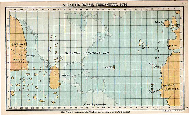
Enter image description here

You can see that not only did it have no concept of Greenland, but where it actually exists would be much further from where he thought the Indies were than the Canaries. Not only that, but Columbus thought the Indies were even closer than this map shows*. To be exact, he thought the Canaries were only 3,700 km from the Indies (rather than 20,000!).

What he did have was a correct conception of the trade winds in the Atlantic. These blow in roughly a clockwise direction in the northern hemisphere. What this means is that if you try to sail from the Canaries straight west, the winds will be helping you. However, if you try to sail from Greenland southwest, you'd be going straight into the wind. So even if it were an otherwise good route that someone knew about, sailing that direction from Greenland would not be an efficient way to cross the Atlantic.
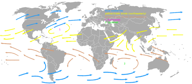
Enter image description here

* - He underestimated the distance between those longitude lines

10
  • 7
    Thats a fantastic answer that really puts things into perspective! Feb 22, 2017 at 15:36
  • 2
    @DrZ214 It's a mythical island - en.wikipedia.org/wiki/Antillia
    – SPavel
    Feb 22, 2017 at 16:20
  • 3
    @DrZ214 - The last time the Norse Greenlanders were contacted by Europeans was 1410. The Chinese did invent something similar to a printing press (which didn't really catch on there), but that isn't really germane to a discussion about European information reproduction and dissemination capabilities.
    – T.E.D.
    Feb 22, 2017 at 16:26
  • 9
    @DrZ214: Cipangu = Japan. Europeans knew little about it, other than the mere fact of its existence.
    – jamesqf
    Feb 22, 2017 at 19:34
  • 3
    You could also add that the type of ship he used had a rather primitive sailing rig - so he would have much greater difficulties to sail against the winds as more modern ships. Basically, ships have to beat against the wind, and his ships would have needed to use much longer triangles to do that. Feb 23, 2017 at 7:01
22

Let's suppose that Columbus knew about Greenland.

  1. European colonies in Greenland were abandoned by that time. Therefore sailing there was actually useless, because it would be impossible to get supplies (except for fresh water) or guides there. It was just an empty island.

  2. He thought that east Asia was closer, so the estimated distance between Asia and Spain was almost the same that the distance between Greenland and Spain. So Greenland wasn't close.

  3. Greenland latitude is 60°, while the known areas of Asia were below 40°.

But, probably Columbus didn't know about early Viking explorations, and the routes they followed.

Finally, exploration in North America for a passage to Asia was after Columbus travels, when they realized that a whole continent was in the middle of the ocean between Europe and east Asia.

10
  • 1
    Point number 1 is valid, but the way I was thinking of it was to use Greenland as a reference and fallback, not a supply stop. If they could make it across the mid-Atlantic without resupply, then surely they could make it to Greenland, then change course. This would get them the farthest West possible without going into unknown territory.
    – DrZ214
    Feb 22, 2017 at 13:01
  • 4
    I'd also slightly quibble with #1. It wasn't "just an empty island". There were people living there in the late 15th century. However, those people were all Thule (Inuit).
    – T.E.D.
    Feb 22, 2017 at 14:23
  • 1
    @MichaelSeifert - So proper in fact, I'm modifying the comment a bit. However the Inuit people living there today are their descendants, and "Thule" is more of an archeological name, so I think its still useful to identify them as "Inuit" as well. YMMV, but I try to give deference to the sensibilities of modern native peoples where reasonable (otherwise my sister may beat me up).
    – T.E.D.
    Feb 22, 2017 at 14:39
  • 4
    @DrZ214 But they weren't trying to "get the farthest west": they were trying to get to the East Indies. Using Greenland as a "reference and fallback" would be like using Chicago as a "reference and fallback" on a journey from Texas to Florida, with the bonus of probably not knowing that Chicago even exists. Feb 23, 2017 at 1:26
  • 1
    @DrZ214 You are consistently ignoring the (simple) fact that Columbus knew of the Atlantic Trade Winds. Going to Greenland (or even a Northerly Great Circle course, which does not go to Greenland) would have had him tacking to such an extent in his ships that they'd have run out of food and water long before making it to the Indies. Ships sailed almost due West from the Azores, Returning to Europe, they made the circle North, with the Winds.
    – CGCampbell
    Feb 23, 2017 at 3:59
5

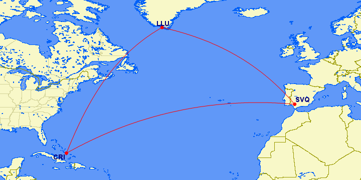
The question seems to be based on something of a false premise. Although the great circle routes from Europe to north American cities do often pass close to or over Greenland, Columbus was starting from close to the southern tip of Europe and he ended up in the Caribbean. His first voyage was from Palos de Frontera and he initially made land on Plana Cays, Bahamas. That's pretty close to being Seville to Crooked Island, and the great circle route between those two points is as follows, with the route via an airport at the southern tip of Greenland shown for comparison.

enter image description here Image source: gcmap.com.

The direct route shown is the shortest possible route, ignoring all practicalities of sailing, but two things can be seen immediately. First, it goes nowhere near Greenland. The direct route is 4100 miles but going via Greenland adds nearly 30% to that. Second, the great circle route involves initially sailing almost due west: the initial heading is 278°, which is only slightly north of due west.

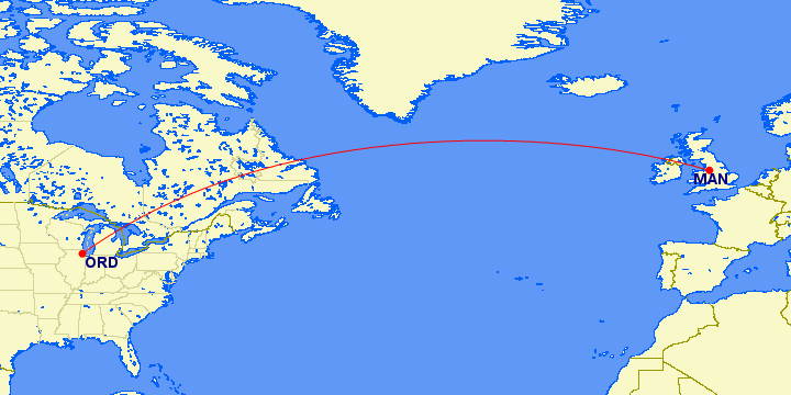
The only routes from Europe to North America that go close to Greenland are those from northern Europe to points north or west of the US Midwest. For example, even Manchester to Chicago misses Greenland quite comfortably if the shortest route is taken (which it isn't always, since the route actually taken depends on winds and traffic).

enter image description here Image source: gcmap.com.

2
  • Right, but Columbus did not know the exact destination coordinates nor exactly how far the distance would be. If the radius of Earth was bigger by 2 or more times, going near Greenland would make more sense from a least-distance perspective. (The original point was that Greenland makes sense from a most-west starting point perspective, which should begin a least distance through unknown waters, but again, assuming you know the exact destination coords.) I marked a correct answer by T.E.D. due to trade winds.
    – DrZ214
    Feb 25, 2017 at 13:11
  • 2
    @DrZ214 But, as TED's answer says, Columbus thought the distance to the Indies was even shorter than the distance he actually travelled to the Caribbean. He thought he was travelling about 3,700km and he ended up travelling about 4,100mi (6,600km). If he thought he was travelling only 3,700km, he should have set off even less far north! Feb 25, 2017 at 15:49
4

General navigation practice of the time was to find your latitude, and then sail along that parallel until you reached your destination, as determining longitude was problematic at best. It also happened to give him the best use of the direction of the trade winds (blowing west from his departure point)

Your Answer

By clicking “Post Your Answer”, you agree to our terms of service and acknowledge you have read our privacy policy.

Not the answer you're looking for? Browse other questions tagged or ask your own question.