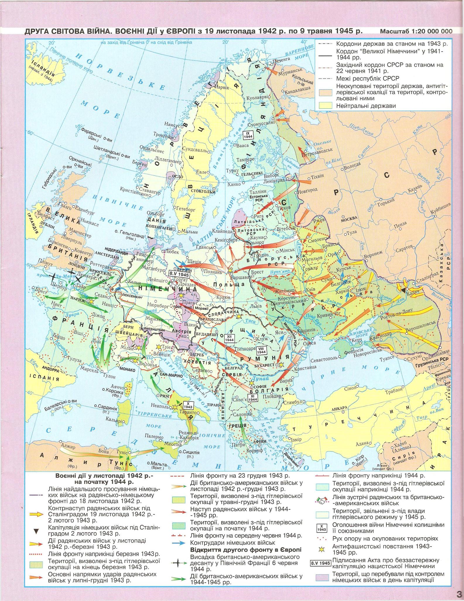
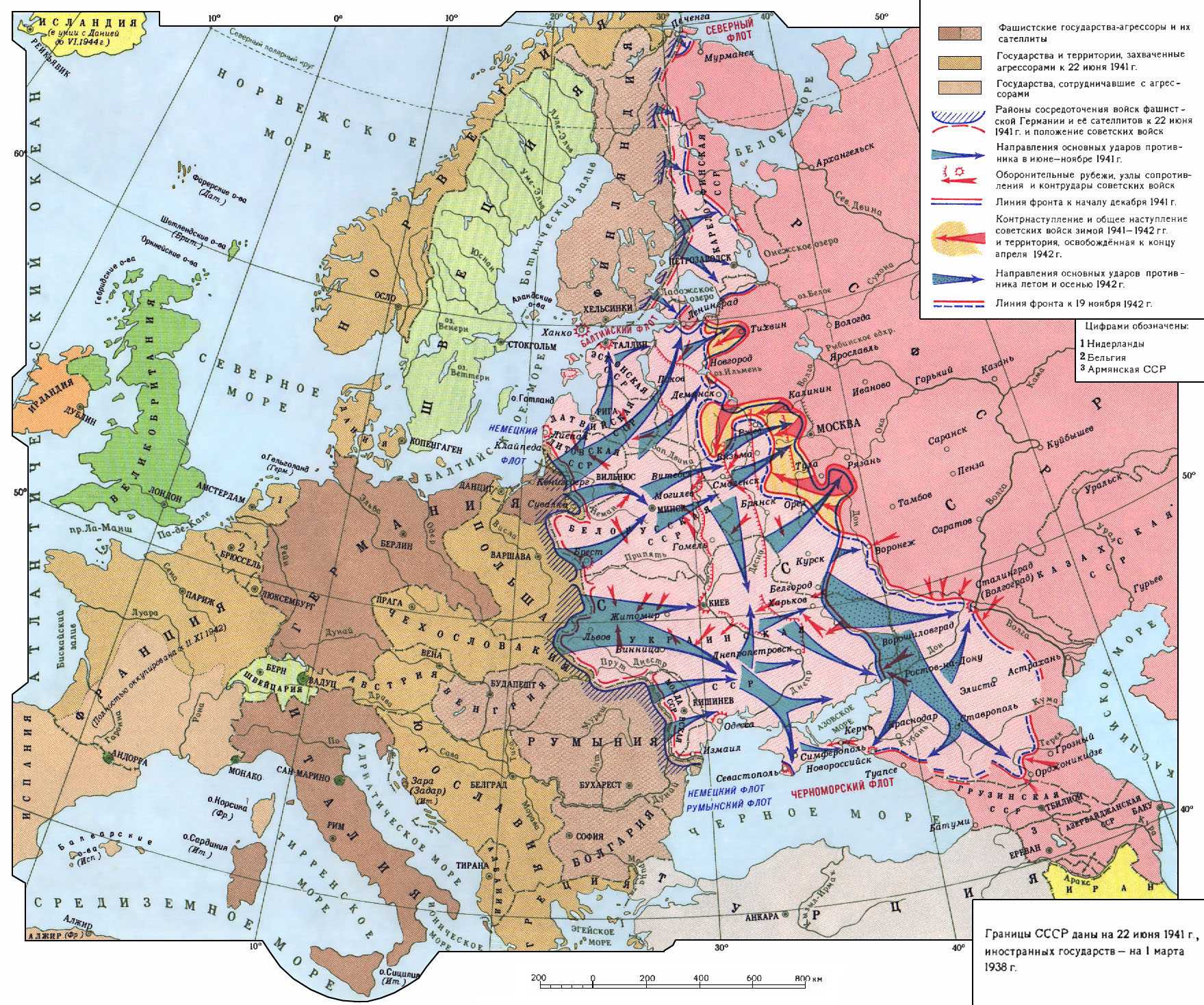
11

I am well aware that the German invasion of the Soviet Union, as depicted on maps like these, showed large German gains in 1941, and subsequently on the road to Stalingrad in 1942.

My understanding, however, was that these gains were mainly in the Baltic States, Belorussia, and the Ukraine, and that only a little of "Russia" proper (as we might define it today) was occupied by the Germans, except for the seesaw fighting on the road to Moscow from October 1941 to say, March 1942, during which almost 100,000 square miles of the country was captured and liberated. A similar "exception" can be made for land between the Don and Volga Rivers in late 1942 that the Germans occupied for a few months before losing the battle of Stalingrad. If anything, Russia gained troops, civilians, and factories that were withdrawn from the non-Russian part of the Soviet Union in anticipation of German occupation to compensate for lost territory.

How much of "Russia" (of 1941) was occupied by the Germans at 1) its maximum extent in December, 1941 and/or 1942? and 2) after the successful conclusion of the Russian winter counteroffensives? (Please use Germany's March 1943 recapture of Kharkov as the end of the Russian 1943 counteroffensive.)

My problem is that I am not sure how to define "Russia." I want the 1941 "predecessor" to today's Russia (post war changes probably mean that they are not exactly the same)." My best guess is that the best proxy for "Russia" is the Russian Federalist Soviet Republic, assuming it is in fact the best "predecessor."

Put another way, the question is how much of German-occupied territory was "Russia" (however defined) as opposed to the rest of the Soviet Union?

9
  • 2
    What do you mean by "Russia"? Are you talking about the RSFSR (Российская Советская Федеративная Социалистическая Республика) or something different than that? If you are defining "Russia" in some special way, you will need to be specific about what borders you are talking about. Commented Dec 28, 2015 at 17:53
  • How might we define "Russia proper" today? The Russian Federation, or a subset thereof? As @TylerDurden points out this probably should be clarified.
    – Semaphore
    Commented Dec 28, 2015 at 18:01
  • You'll have to define the borders of Russia before the question can be answered. In 1941 there was no legal entity known as Russia - there was a Russian Federated Socialist Republic. I think those borders are depicted on the map you reference.
    – MCW
    Commented Dec 28, 2015 at 18:09
  • 2
    It is a trivial question: the answer can be easily found on Internet. I vote to close.
    – Alex
    Commented Dec 28, 2015 at 20:02
  • @Alex: see Mark C. Wallace's comment. "You'll have to define the boundaries of Russia." I have found plenty of statistics and references to the German occupied Soviet Union, but not to "Russia."
    – Tom Au
    Commented Dec 28, 2015 at 20:24

4 Answers 4

17

Let me start from your next to the last question:

... the best proxy for "Russia" is the Russian Federalist Soviet Republic. Is it comparable to today's Russia?

Yes, it is compatible to the Russian Federation of today. There are a couple of exceptions.

In 1941 Russia had not:

  • the Kaliningrad region (the northern part of East Prussia, which was incorporated in 1945);
  • Tuva (which joined voluntarily in 1944);
  • the Pechengsky (Petsamo) region (which has rather complicated history of Finland/USSR affiliation, but it seems that the last time when some of its lands were transferred is 1947).
  • the Karelo-Finish SSR, which was a standalone republic of the USSR, that is not a part of the RSFSR, but today it is a part of the Russian Federation.

Also depending on one's attitude to the Crimean referendum and the subsequent events one can say that today Russia has not the Crimea as its part, but anyway Russia had it in 1941.

Also one should take into consideration that the borders of Russia with Ukraine, Belarus, Estonia and it might be Latvia are not demarcated, so there is no "inch precision" on the land.

Next.

Or is there a better definition of Russia (perhaps with the benefit of hindsight) for the purpose of this question

There are innumerable definitions of Russia, and which is the best is greatly dependent on one's political views. Even a definition with some ethnic approach is very unreliable and slippery, if you want to follow this way, good luck, if you find any sources which you will consider trustworthy.

So let me stick to the definition of Russia as the Russian Federation of today (including the Crimea), except those parts, which were not parts of the USSR in 1941, that is the Pechengsky region and Kaliningrad one, because you asked about "Russia" of 1941.

How much of "Russia" (of 1941) was occupied by the Germans at

... its maximum extent in December, 1941 and/or 1942?

This is what was occupied in 1941 (the red hand-drawn line) and liberated during the counter-offensive in December 1941 - April 1942 (the green hand-drawn line). The lines were drawn according to the map itself, which is not 100% accurate (at least, I have spotted the absence of the Izyum salient and the Kerch peninsula in the Crimea is not marked as liberated, though it was in the late 1941). The orange hand-drawn line is the current borders of Russia including the Crimea and excluding the Pechengsky region and Kaliningrad one. As a sidenote to that map, the other dark blue part of the map to the east of the red line is what the Germans captured in 1942 (including Sevastopol and the Kerch peninsula in the Crimea).
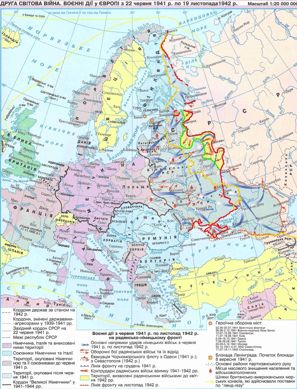
the German advance and the borders of Russia in 1941

How much of "Russia" (of 1941) was occupied by the Germans at

... after the successful conclusion of the Russian winter counteroffensives? (Please use Germany's March 1943 recapture of Kharkov as the end of the Russian 1943 counteroffensive.)

This map shows (besides other things) the 1942 German advance (the red hand-drawn line) and subsequent Russian counter-offensive until the German recapture of Kharkov in March 1943 (the green hand-drawn line). The orange hand-drawn line is the current borders of Russia including the Crimea and excluding the Pechengsky region and Kaliningrad one.
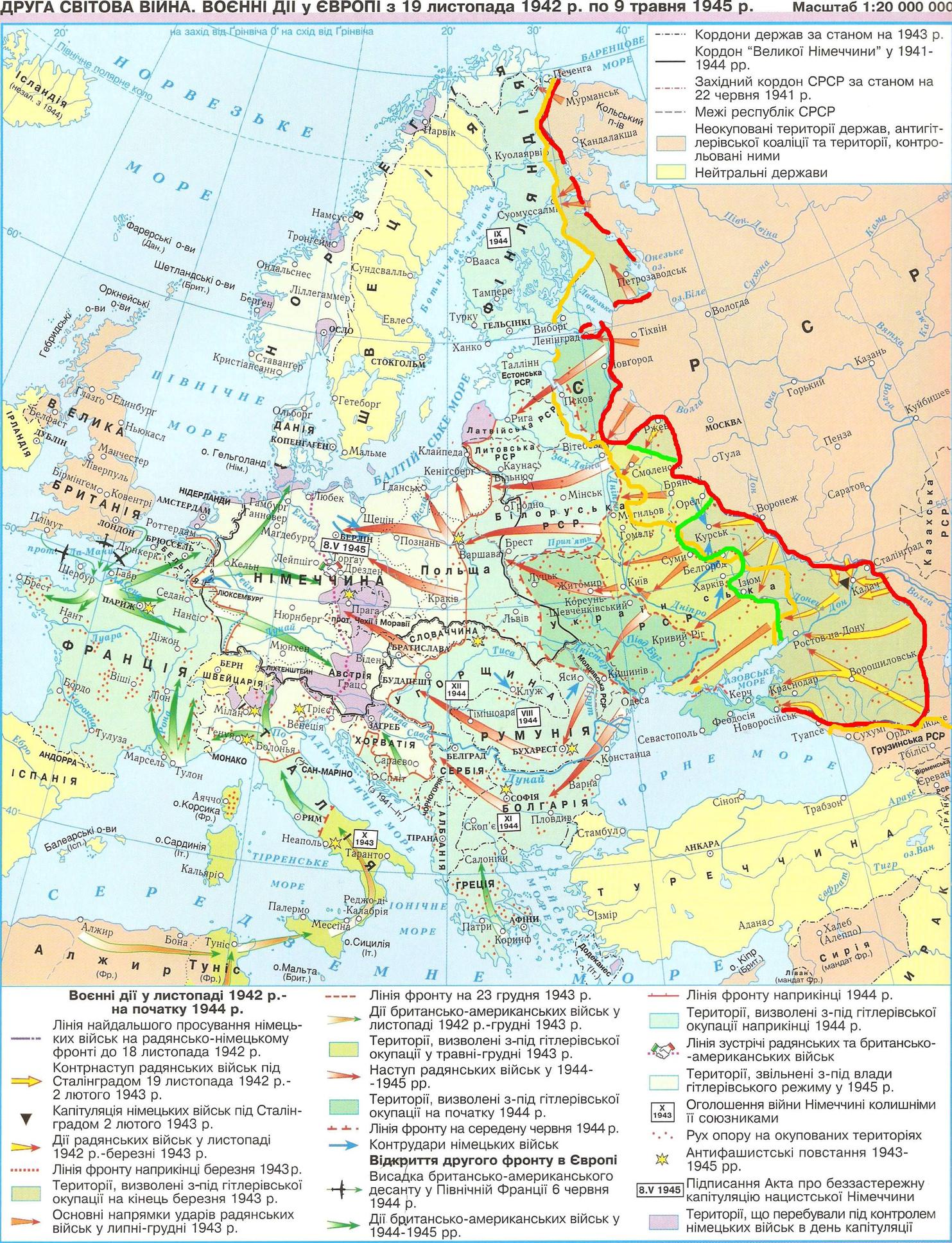
the German advance in 1942 and the borders of Russia in 1941

Is it true that occupied Russia was "small" compared to the rest of the occupied Soviet Union?

If you mean "small" in the meaning of the area, you can compare these using the maps, sorry I failed to find any reliable source with numbers. The large part of the RSFSR was occupied in 1942, but it was a much shorter period under occupation (7-8 month), than Belarus, for instance, had (three years), so I suppose Germany was not able to exploit these lands to such extend, as it did in the western parts of the USSR.

If you mean "small" in the meaning that Russia suffered less in the war, than other parts of the USSR, I'm afraid it is hard to give an answer without political bias etc. Despite that (in my subjective impression) in our historiography the harshest occupational regime is considered to be installed in Belarus, some parts of today's Russia suffered a lot, like Stalingrad or besieged Leningrad. Also other parts of the USSR which were not occupied (like Uzbekistan, Kazakhstan, Turkmenia, Tajikistan) provided their own effort and suffering for the victory.

Hope, that has answered your questions, the next are original maps without my hand-drawn lines:
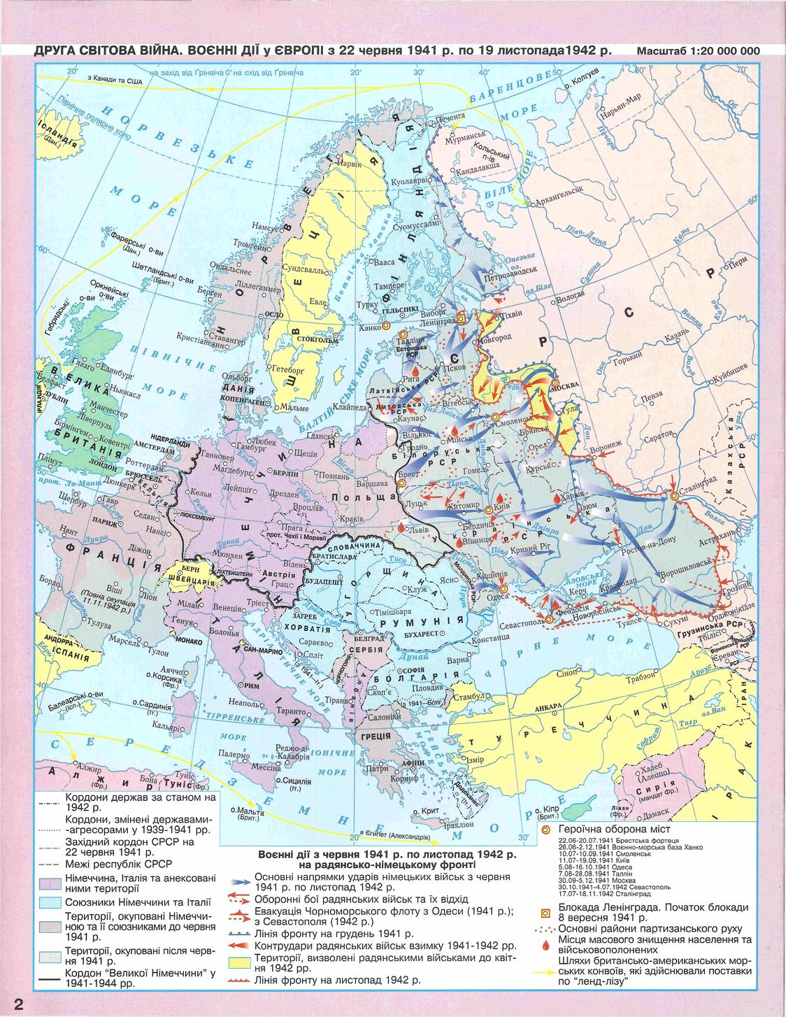
WW2 in Europe 1941-1942 WW2 in Europe 1942-1945

5
  • the harshest occupational regime is considered to be installed in Belarus The absolute numbers of victims in Ukraine is somewhat bigger, yet Belorussia was three times less than Ukraine in both area and population, so the choice is obvious. Considering occupied territories of RSFSR, Nazis hadn't enough time to run the holocaust machine, which really makes the difference.
    – Matt
    Commented Dec 30, 2015 at 9:57
  • 2
    @Matt: Nazis did run the Holocaust in Russia except regions lost by them as early as in 1941/42 winter; mostly near Moscow and Tver. Some parts of Russia—mainly in the South—suffered greatly. But there were not so much Jews and Roma in occupied Russia as were in Ukraine and Belarus – it’s this making the difference. Nazis didn’t waste time exterminating Jews in Rostov-on-Don and killed most of them in the first day. Commented Aug 12, 2017 at 19:11
  • 2
    If you're going to mention Tuva, better also mention South Sakhalin, the Kurils, and Habomai and Shikotan, all of which are part of Russia today but weren't in 1941.
    – Vikki
    Commented Sep 22, 2021 at 2:03
  • Yes, thank you for the suggestion. Will do later, unless someone else edits the answer. Sorry, don't have time now.
    – d.k
    Commented Sep 23, 2021 at 8:55
  • 1
    It should be noted that the occupied area might not be very big compared with the enormous area of Russia, but it was (and still is) the most populated and the richest part of Russia.
    – Pere
    Commented Oct 15, 2021 at 20:11
8

maximum extent in December, 1941

It wasn't really the "maximum" extent. The territory, which the USSR fought back in winter 1941 - spring 1942, was much less than the area occupied by the German army while advancing to Stalingrad. The following map clearly demonstrates this.

enter image description here

The "yellow" area is what the USSR gained. Germany's gain is on the south between the two front-lines: Voroshilovgrad (now Lugansk, Ukraine), Rostov-na-Donu, Krasnodar, Stavropol, Elista, etc. - all belong to the RSFSR (and modern Russia).

Also the losses of 1941 included more than just "the road to Moscow". These were large cities (of the RSFSR) such as Smolensk, Belgorod, Bryansk, Kursk, Orel, Pskov etc.

Is it true that occupied Russia was "small" compared to the rest of the occupied Soviet Union?

The administrative borders are seen on the map. These areas are more or less comparable. Though the loss of the RSFSR is mostly "thin" and "stretched" from north to south.

Also it's worth noting that although the total occupied area was only about 7% of USSR, yet the total number of the pre-war population of these territories reached about 40% of the whole USSR (Roughly speaking, the pre-war population of Ukraine+Belorussia+Baltics was about 40-45 mln.; the pre-war population of the occupied parts of the RSFSR 30-35 mln.).

Russia gained troops, civilians, and factories that were withdrawn from the non-Russian part of the Soviet Union in anticipation of German occupation to compensate for lost territory

The Western front's troops were utterly defeated in 1941. Actually many armies were created anew (i.e. regular divisions were disbanded, and newly formed volunteer divisions got their ids).

Factories of Ukraine and Belorussia (mostly) could not be evacuated due to fast enemy advance. What the SU evacuated successfully were factories of the European part of the RSFSR (including the Moscow industrial region). They went as far as Ural, which was a big time loss for the SU. And factories still remaining relatively close to the front were constantly under Luftwaffe's attacks.

7
  • 1
    "The total occupied area was only 7% of the USSR," but the richest, most populous 7% of the USSR. How much of that 7% was "Russian" as opposed to "non-Russian?"
    – Tom Au
    Commented Dec 28, 2015 at 20:49
  • @TomAu Well, the map has administrative borders, as I said. My best estimate is about 1 mln. km. for Ukraine+Belorussia+Baltics+Moldova; and 600-900 th. km. for RSFSR.
    – Matt
    Commented Dec 28, 2015 at 21:08
  • Using a midpoint of 750,000 of your estimate for RSFSR, a ratio of 3 to 4 for Russia versus non, that is 3% of the Soviet Union. Is that at Germany's "high water" marks of 1941 or 1942, or after the respective "rollbacks" of spring 1942 and spring 1943?
    – Tom Au
    Commented Dec 28, 2015 at 21:11
  • @TomAu "Somewhere between Dec.1941 and 19.11.42 (Operation Uranus)" would be Okay?
    – Matt
    Commented Dec 28, 2015 at 21:16
  • 2
    @TomAu Not really temporarily. The spring 1943 offense (after Stalingrad victory) was a failure. So Germany held both Ukraine border and Smolensk bridgehead until autumn 1943. This is why the battle for Kursk is as famous as for Stalingrad.
    – Matt
    Commented Dec 28, 2015 at 21:34
3

The map given in Matt's answer shows what the Germans really occupied. The remaining question is what it really means Russia or "Russian territories". I think Tom Au had to specify this exactly when he was asking this question. But I can comment on this.

Double click on the map and you will see the administrative boundaries within Soviet Union. They are shown like this ----- and these are the boundaries between the "Soviet republics" as of 1939.

So if the question is how much of the Russian Federation (in the boundaries of 1939) the Germans occupied, the answer is also clear from the map.

Since then the boundaries of the Russian Federation changed. So modern Russia does not coincide with 1939 Russian Federation. The largest changes are Kaliningrad region (former East Prussia, historically German territory, shown in brown) which was annexed from Germany, and Crimea which was transferred to Ukraine, and then invaded and annexed by Russia in 2014.

But the question is more complicated/ambiguous than that, because Russia itself contains the so-called "autonomous republics" and "autonomous regions" where a great part of population, sometimes majority, is not ethnically Russian. The boundaries of these regions are not shown on this map. This mostly concerns North Caucasus, the place where the Germans penetrated furthest to the East.

The "Russian" cities shown on the map are the following: (NW to SE) Petrozavodsk (Karelia autonomous republic), Pskov, Demiansk, Novgorod (on the boundary of the occupied zone), Rzhev, Vyazma, Smolensk (disputed between Russians and Belorussians, Poles and Lithuanians for centuries) Bryansk, Orel, Kursk, Belgorod (on the very boundary of Ukraine), Voronezh (on the boundary of the occupied zone).

Then go (SE of Ukraine) Rostov, Krasnodar, Kerch (the region where Don Cossaks live, once all this was Ukraine) and Crimea peninsula (populated by Tatars, Ukrainians and Russians, currently occupied and annexed by Russia from Ukraine), Elista (autonomous Republic of Kalmykia, now part of Russia, in 1939 part of Russian republic), Stavropol (North-Caucasus Krai, with very mixed population. The large occupied region around Stavropol consists of 6 autonomous republics: Kalmykia, Dagestan, Chechen Republic, North Ossetia–Alania, Kabardino-Balkar Republic and Karachay–Cherkess Republic).

All other cities in the occupied territory shown in this map are in Baltic republics, Belorussia, Ukraine, and Moldowa.

Visually the pink part which is in the Russian republic of 1939 is about 1/4 to 1/3 of the whole pink part. But the regions occupied by the ethnic Russians is probably 1/5 of the pink area.

2
  • 4
    Counting "ethnic population" outside administrative borders is too error-prone. If you really want to do this, you have to add 10-15% of Russian minority in Ukraine and Belorussia, at the very least.
    – Matt
    Commented Dec 29, 2015 at 7:36
  • @Matt: of course I agree with you and this is why I did not count:-)
    – Alex
    Commented Dec 29, 2015 at 16:11
1

In round figures, the Germans occupied about 700,000 square miles of the Soviet Union in 1941 (at their peak). Of this, roughly 500,000 square miles represented former Soviet Republics: the Baltic states, Belarus, the Ukraine, etc. Another 100,000 represented territory occupied by the Soviets between 1939-1941: eastern Poland, and parts of Romania and Finland. The remainder, about 100,000 square miles, were part of modern day Russia.

This compares with 1.5 million square miles for "European" Russia (in today's terms), so the Germans occupied 6%-7% of European Russia at their 1941 high point. This was somewhat more for the summer/fall of 1942, but the Germans quickly lost most of those gains.

The "buffer states" and the "border regions" did provide a high, though imperfect degree of protection for Russia against German invasion/occupation.

Sources: Various Wikipedia "country" articles on land area.

Your Answer

By clicking “Post Your Answer”, you agree to our terms of service and acknowledge you have read our privacy policy.

Not the answer you're looking for? Browse other questions tagged or ask your own question.