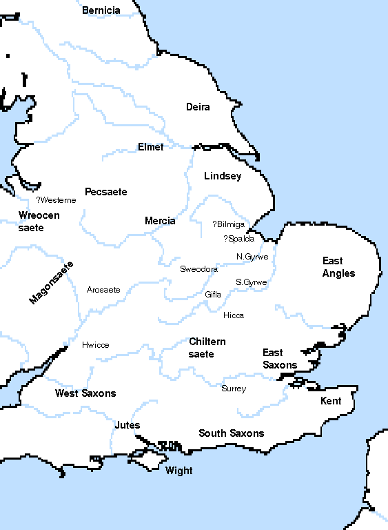
The Tribal Hidage set out the number of households living in different kingdoms and sub-kingdoms of Anglo-Saxon England. Has any work been done to map this data, in particular comparing it to the detailed records of the Domesday Book or other detailed censuses closer to the time? In particular I'm interested in the smaller "Middle Angle" tribes mentioned such as the Gifle, Hicca and Willa.
2 Answers
According to wikipedia, yes several people have done various mappings against known historical documents, although I can't find anything to the level of detail I'd like.
Sir Henry Spelman was the first to publish the Tribal Hidage in his first volume of Glossarium Archaiologicum (1626) and there is also a version of the text in a book written in 1691 by Thomas Gale, but no actual discussion of the Tribal Hidage emerged until 1848, when John Mitchell Kemble's The Saxons in England was published. In 1884, Walter de Gray Birch wrote a paper for the British Archaeological Society, in which he discussed in detail the location of each of the tribes. The term Tribal Hidage was introduced by Frederic William Maitland in 1897, in his book Domesday Book and Beyond. During the following decades, articles were published by William John Corbett (1900), Hector Munro Chadwick (1905) and John Brownbill (1912 and 1925). The most important subsequent accounts of the Tribal Hidage since Corbett, according to Campbell, are by Josiah Cox Russell (1947), Cyril Hart (1971), Wendy Davies and Hayo Vierck (1974) and David Dumville (1989).[39]
- Hart, The Tribal Hidage, pp. 135-136, 156.
- Hill and Rumble, The Defence of Wessex, p. 183.
"Domesday Book and Beyond: Three Essays in the Early History of England" includes a high level comparison of Tribal Hildage, Burghal Hildage, and other documents with the Domesday Book. One of the issues pointed out here is the uncertainty of definition of the 'hide' unit of measurement. Since these were taxation documents it was advantageous for people to misstate things to their advantage, and this can be seen in obvious discrepancies between subsequent documents. Domesday allocates 70,000 hides to the whole of England, whereas in the Tribal Hidage it comes to well over 240,000 hides.
Another reference that sounds interesting (but not available online):
- http://www.lib.unc.edu/mss/inv/l/Lemcke,Ernest_Gustave.html - Unpublished manuscript with maps entitled "The Tribal Hidage or First English Census" by Ernest Gustave Lemcke, a study of the so-called Tribal Hidage, printed in Birch, dealing with the geography and demographics of England in the 7th century.
Maps

I've managed to find this for a start:
The Gifle (300 hides), located in eastern Bedfordshire (map here on page 10)